GROUNDWATER
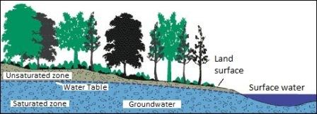 Groundwater is water below ground, filling up pore spaces in soil and joints in rocks. The water table is the depth to the surface of the saturation zone, the area of soil and rock that is saturated with groundwater.
Groundwater that is naturally close to the surface can cause wet conditions. High groundwater is generally found in low lying parts of the landscape, especially in floodplains next to perennial streams. Water seepage can also be found on slopes from natural springs. Groundwater is generally closest to the surface in colder months, but wetness can occur throughout the year. Click on image to enlarge.
GULLY AND GULLY EROSION
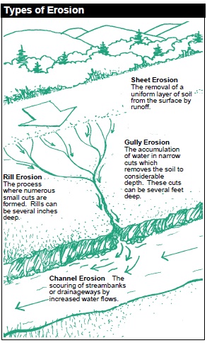 A gully is an incision or ditch created by the flow of running water. In the process of gully erosion, running water picks up soil or sediment in its path and moves it downstream, often depositing it into streams, lakes and rivers. Click on image to enlarge. Compare with Sheet Erosion.
INFILTRATION
Infiltration is the rate at which water passes through soil, generally measured in inches per hour. Soils with high clay content or compact soils have slower infiltration while loose or sandy soils have a higher infiltration.
It is important to conduct an infiltration test prior to installing a rain garden or dry well. If your soil has poor infiltration at the bottom of the rain garden, you will likely need an underdrain. You can use the following steps to assist you in conducting an infiltration test.
How to Conduct an Infiltration Test:
- Dig a 12-inch (or deeper) hole at the proposed site of your rain garden or dry well and fill it completely with water.
- Allow the water to sit for at least an hour so that the soil can saturate.
- Refill the hole so it is full.
- From this point on, observe to see if the water drains into the soil.
- If the water drains within 48 hours, the site is suitable for a rain garden or dry well; however, it is highly recommended that the soil be amended with some compost and sand.
- If the water does not drain in 48 hours, select a different location or amend or replace the soil and install an underdrain. It may be easier to choose another location.
- You may choose to run the infiltration test more than once in the same hole or in different holes to ensure an accurate result.
See also: Permeability.
LANDSCAPE FABRIC
Also called filter fabric or geotextile fabric. Landscape fabric is now typically made of synthetic (plastic) woven material. It is used to cover bare soil to prevent erosion. The tightness of the weave varies. In situations where water should not pass through the fabric, the weave should be tight. Looser weaves should be used when water is intended to pass through the fabric. Natural (non-synthetic) landscape material is a biodegradable option that can be used as an erosion control blanket until plant roots take hold.
MISS UTILITY
 Miss Utility, also known as Virginia Utility Protection Service (VUPS), is a free service that provides markings for underground utilities, including power, sewer, gas, water and cable lines. Miss Utility can be contacted by dialing 811 (in Virginia) or 1-800-552-7001.
NATIVE PLANTS
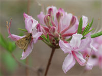 A native plant is a plant found in the ecosystem in which it has evolved. It exists in equilibrium with other species in the same ecosystem. In the United States, plants found in the country prior to European colonization are considered native. People everywhere are discovering the beauty and benefits of native plants, from canopy trees to shrubs to meadow species and native groundcover. They help restore the ecosystem as more land is cleared for buildings or roads. They can require less maintenance than other plants. They also provide food and shelter for people and wildlife.
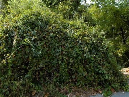 Invasive plants are aggressive non-native plants. These plants grow out of control when taken out of their native ecosystem. Kudzu or "the plant that ate the South" is an invasive that is commonly known. Invasive plants frequently escape from yards. Examples include English Ivy, Bamboo, Japanese Honeysuckle, and Garlic Mustard. For a full list of invasive plants that are problematic in Fairfax County, as well as how you can help, see Invasive Management Areas.
PERMEABILITY
The rate at which water passes through soil. Soils with high clay content or compact soils have slower permeability while loose or sandy soils have a higher permeability. See also: Infiltration.
PLAT
A map showing the boundaries and key features of a property. Similar to a plan or blueprint of a house or interior space, a plat of a lot shows the characteristics of the exterior space.
PROBE
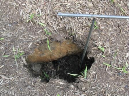 A soil probe is a long metal rod with a handle. It is particularly useful for determining the depth, size and extent of a sinkhole. If a probe is not available, a piece of rebar, shovel, fireplace poker or other implement can be used.
RESOURCE PROTECTION AREA
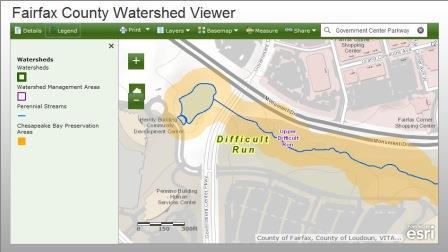 Perennial streams, coastline, wetlands, or other water bodies, and a buffer area (usually 100 feet) are protected as Resource Protection Areas, also known as Chesapeake Bay Preservation Areas. Soil disturbance, land clearing or development within an RPA is highly restricted and contingent upon permission from the County.
To determine if your property is in an RPA, use the Fairfax County Watershed Viewer. Enter your address to find your watershed, nearest stream and Resource Protection Areas. You can also contact the Conservation District(703-324-1460, TTY 711). District staff can help explain your options if your land is in an RPA.
RIPRAP
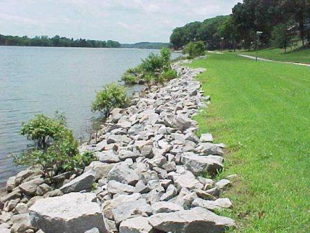 Riprap consists of large rocks used to reduce water velocity at the outfall of pipes or to reduce erosion by flowing water on soil surfaces or in stream beds.
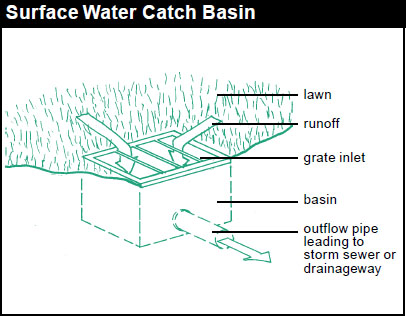
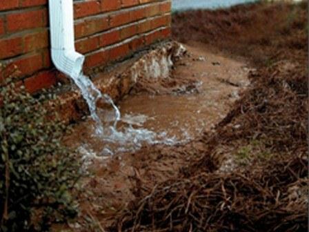
RUNOFF
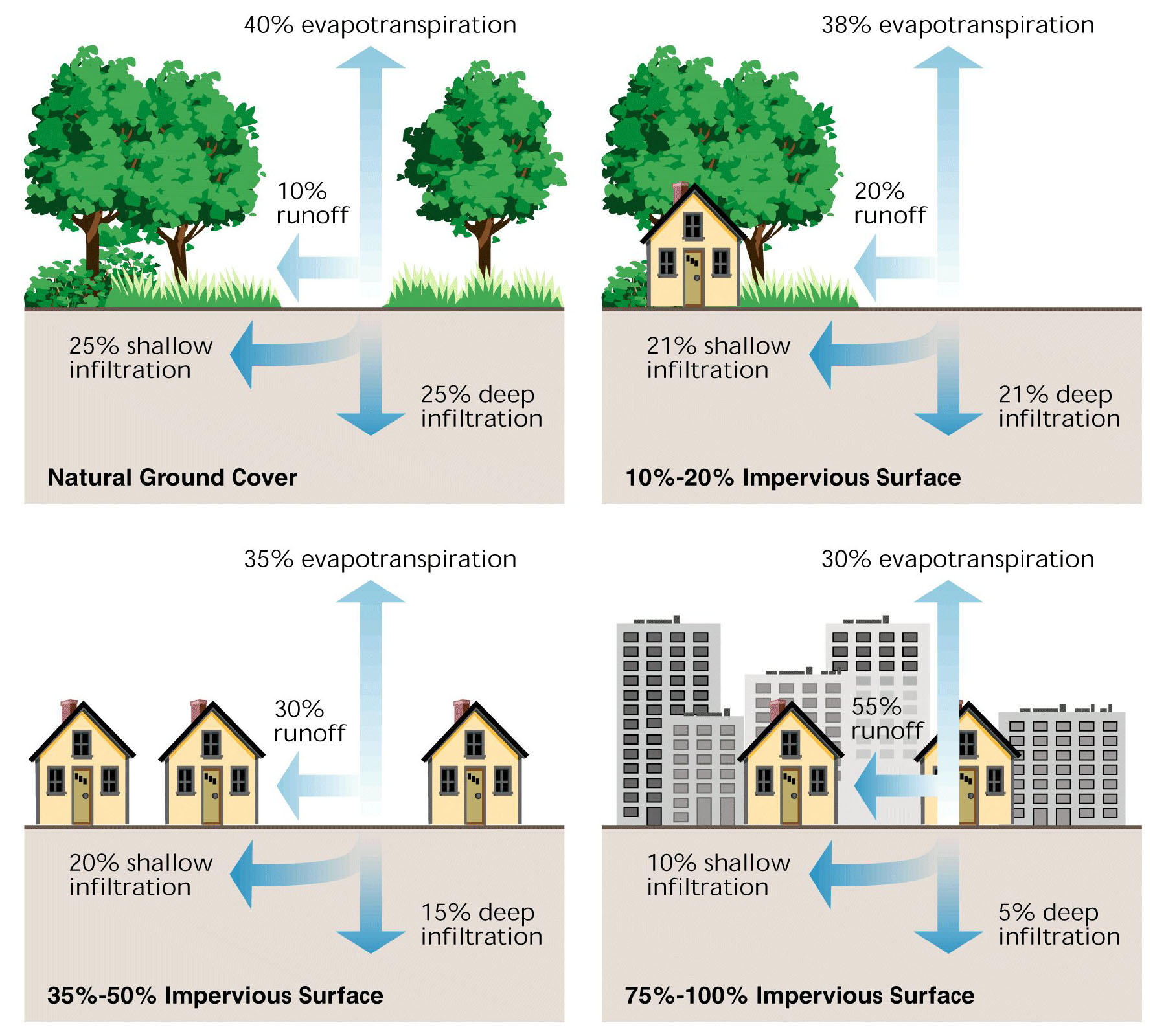
 Runoff is the flow of water over land that does not infiltrate into the soil or evaporate into the atmosphere. Runoff can come from rain, melting snow or even hoses or sprinklers. Problems with runoff are exacerbated by impervious surfaces that prevent infiltration such as roofs, roads and driveways. Click on image to enlarge.
SHEET EROSION
The removal of a uniform layer of soil from the surface by water runoff. Click on image to enlarge. Compare with Gully Erosion.
SOIL TEST
 A soil test is the best way to determine if your soil needs a pH or nutrient change. A soil test kit can be obtained from Fairfax County libraries or the Soil and Water Conservation District office. You can mail your soil sample to Virginia Tech and receive a detailed report for a small fee of $10.
Tips for reading your soil test report and applying fertilizer or lime:
- A soil test can help you avoid fertilizer burn, when too much fertilizer kills grass or other vegetation.
- Adequate quantities of nutrients may be present in the soil, but if the soil pH is too acidic, nutrients may not available for plant use.
- Fertilizer recommendation is in pounds/acre (lbs./ac) and should be added once every year.
- Lime recommendation (for pH) is in tons/acre and should be added only once in three years.
- After a period of three years, a new soil test should be performed.
After correcting the pH or nutrient level, re-seed or replant the appropriate vegetation of your choice.
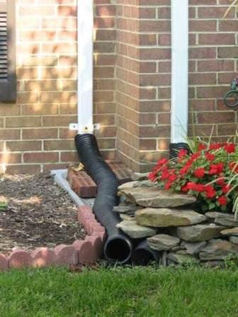
SPLASH BLOCK OR SPLASH GUARD
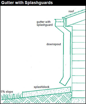 A plastic or cement plate placed at the end of a downspout to disperse and slightly slow down runoff and protect the underlying soil. Click on image to enlarge.
SUITABLE OUTLET OR AREA
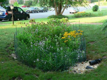 A suitable outlet is an area of land that is capable of receiving redirected runoff without causing erosion or sogginess. Examples include rain gardens, dry wells, existing swales or gently sloping vegetated land not immediately leading to neighboring properties. Ideally, runoff should be directed to an area where it can soak into the soil, filtering and cleaning the water.
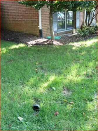
It is best to avoid connecting one impervious surface to another when discharging runoff. For example, from a water quality perspective, it is not preferable to discharge your roof runoff directly onto your driveway, flowing onto the street, into a storm drain and to the nearest stream, where the sheer volume of water flow can cause damage.
Conversely, an unsuitable or inadequate outlet is an area of land that is not capable of receiving redirected stormwater runoff without causing erosion, sogginess or other problems. Examples of inadequate outlets are areas with compacted soil that will cause stormwater to stagnate rather than soak into the ground, steep slopes that will produce rapid runoff and erosion, or areas next to foundation walls or other structures that could cause home flooding if used as a receiving area for runoff. Another example of an unsuitable discharge area is your property line. Don't solve your own issue by creating a problem for your neighbor.
SUMP PUMP
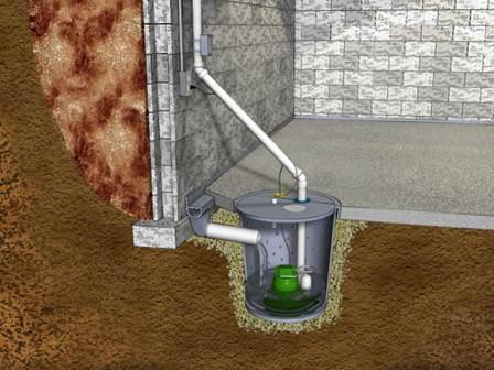 A small reservoir at a low point used to collect water. Many households have a sump designed into the foundation or slab to collect groundwater so it does not flow into the basement. A sump pump is a device that pumps that water through a pipe to the exterior of the house.
SWALE
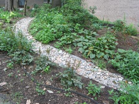
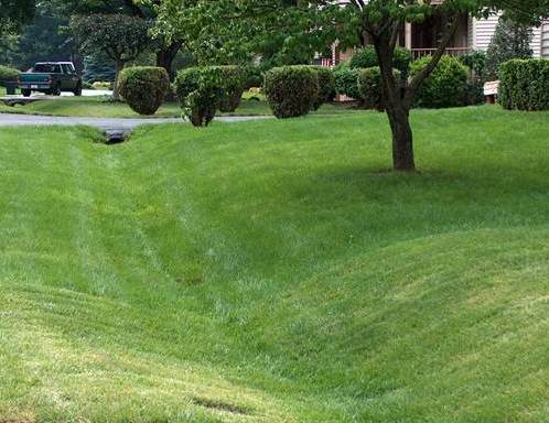 A wide, shallow channel designed to convey water safely. It has gently sloping sides. The swale can be lined with grass or stone to prevent erosion. Swales can trap sediment and pollutants if the water is flowing slowly.
TAMPER
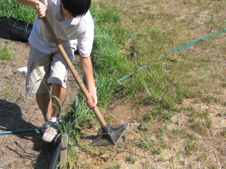 A tamper is a tool used to compact soil. It has a long handle with a flat metal plate at the end. To compact soil, the back of a shovel may also be used.
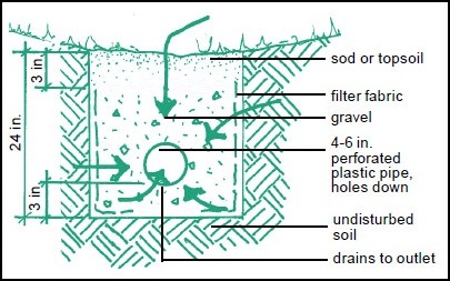
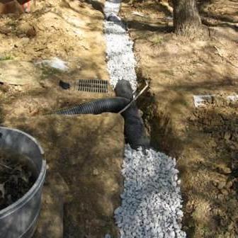
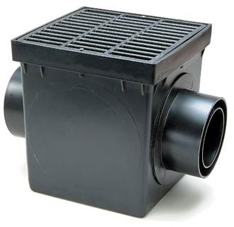
UNDERDRAIN
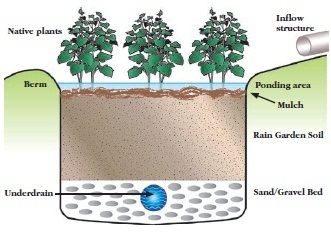 An underdrain refers to an underground drain pipe used with rain gardens or dry wells to allow excess stormwater to be carried away during heavy storms. An underdrain is often necessary in soil with very low permeability. Click on image to enlarge.
UNDERGROUND DRAINAGE SYSTEM
This is a less preferred option for handling widespread wet conditions. An underground drainage system is a series of perforated pipes buried underground to capture flow from high groundwater. It is similar to a French drain, but at a deeper level. The pipes are installed with a very slight grade. Groundwater enters the pipes and flows to a suitable outlet. This is sometimes referred to as drainage tiles, especially in agricultural settings.
WETLAND
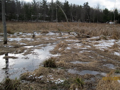 A wetland that meets the Army Corps of Engineers definition is a jurisdictional wetland and is protected under the Clean Water Act. Any disturbance of a jurisdictional wetland in Virginia is prohibited without a permit from the Army Corps of Engineers Norfolk Office or the Virginia Department of Environmental Quality. Some wetlands in Fairfax County are within Resource Protection Areas protected under the Chesapeake Bay Preservation Ordinance.

 Wetness or erosion near your foundation walls and drip line can be very damaging. The source of these problems can include:
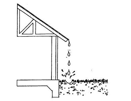
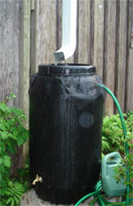 A rain barrel is a large container that attaches to the end of a downspout and stores water for later use, such as watering your garden or lawn. Rain barrels come in many shapes and sizes. A typical rain barrel holds about 50 gallons of water. Larger cisterns can hold hundreds or even thousands of gallons. Rain barrels are simple to install and inexpensive. Unless you have a cistern, this option generally does not provide enough storage capacity to greatly reduce the amount of runoff flowing to the lawn during large storms. Rather, rain barrels are most useful as an addition to other stormwater controls.
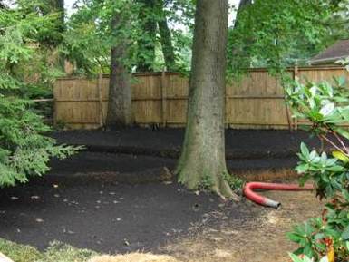 Low intensity method:
 High intensity method:
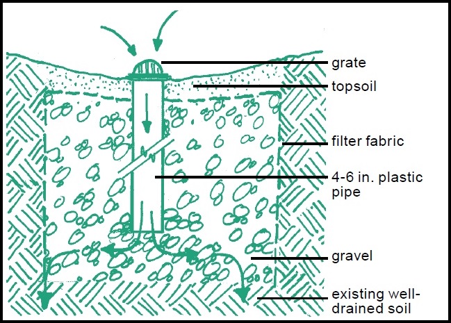 A dry well or infiltration trench is a gravel-filled underground storage area. Water captured by a dry well is stored in the void spaces between the gravel until it infiltrates slowly into the ground or flows out through an underdrain.